"One of the coldest and most savage spots on earth": History and Records of the Automatic Weather Station on Denali
- By Dr. Lea Hartl
- Jul 31, 2023
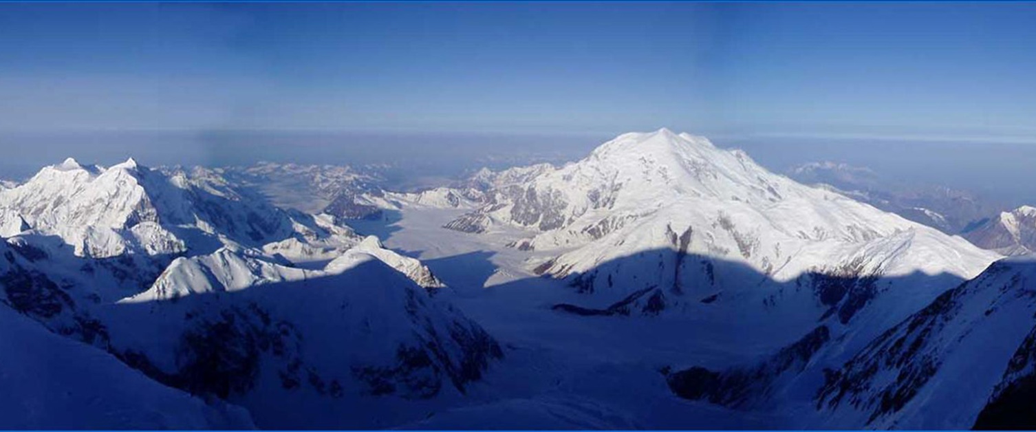
Photo by Tohru Saito. Note from the photographer: The mountain you see is [Mt.] Foraker. The shadow you see is the shadow of Denali around solstice. [This is] the shadow of the tallest mountain when the shadow is shortest. I think the photo was taken early in the am.
A fatal storm
On February 20th, 1989, a three-person team of Japanese mountaineers climbing the West Buttress route on Denali reached High Camp at 5243 m.a.s.l. The team leader, Noboru Yamada, was hoping to become the first person to summit the highest peaks of the seven continents in winter and was climbing with two other experienced mountaineers, Teruo Saegusa and Kozo Komatsu, on this occasion. The weather on the 20th had been relatively calm. Synoptically, Denali was situated between a pronounced trough to the west and ridging in the Gulf of Alaska, in a strong southwesterly flow – a common winter-time pattern in the region (Hartl et al., 2020a).
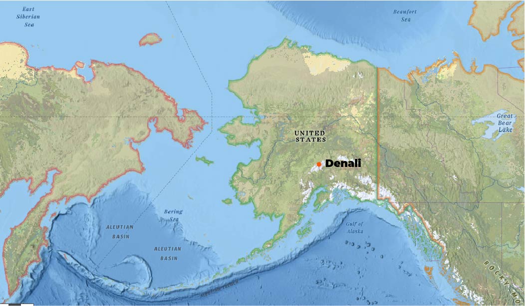
The Japanese group met a descending Austrian team at High Camp. Wind speed picked up noticeably and both groups remained in camp on February 21st due to the severe weather. On February 22nd, conditions briefly cleared and the Austrians continued their descent while the Japanese group remained in camp. Reanalysis data shows wind speed dropping to tolerable values on the 22nd, before increasing again on the 23rd, reaching more and more extreme values in the following days.
The Austrian climbers were the last to see the Japanese team alive. Search flights spotted their bodies on March 10th below Denali Pass. Later in March, a 17-person team from the Japanese Alpine Club recovered the bodies. Hypothermia was determined as the cause of death. Referring to the incident, the National Parks Service (NPS) mountaineering report of 1989 states: “It is believed that the climbers tried for the summit during a brief lull in the severe wind storm and were caught near Denali Pass as the winds again increased.”
Aside from the primary danger of being physically blown over and a subsequent climbing fall in exposed terrain, any injury or equipment failure induced by a fall would have quickly become life threatening due to the very low temperatures. Wind chill equivalent temperature (WCT) dropped below -50°C on the 23rd and remained below -30°C throughout the week. Facial frostbite time (FFT) was in the range of 5 minutes to instantaneous for the majority of the storm. See Moore and Semple (2011) for definitions of WCT and FFT.
Origins of a unique weather station
In the aftermath of the accident on Denali, a debate on the causes developed within the Japanese mountaineering community and questions were raised as to the decision-making of the team leader. A group led by Yoshimoto Okura of the Japanese Alpine Club – himself an accomplished mountaineer – argued that the extreme wind speeds likely caught Yamada and his companions by surprise and that the accident was not the result of a lack of mountaineering experience, but rather a consequence of the extreme weather conditions on Denali. To prove that gusts on Denali Pass reach wind speeds so extreme that climbers can literally be “blown off the mountain”, Okura initiated efforts to install an automatic weather station (AWS) near Denali Pass, at 5715 m.a.s.l., in the following year.
The AWS was installed during the climbing season in 1990 and operated for 10 years by a team of dedicated mountaineers belonging to the Japanese Alpine Club (JAC). The station was then donated to the International Arctic Research Center (IARC) at the University of Alaska Fairbanks (UAF). In total, the AWS was intermittently operational from 1990 to 2007. To our knowledge, the Denali Pass AWS was the world’s highest weather station at the time of its installation. It was the highest station in the Americas until the installation of two AWS above 6000 m.a.s.l. in the Bolivian Andes in 1996 (Hardy et al., 1998). To this day there are no continuous meteorological measurements from higher elevations in North America that we are aware of.
In a joint effort by the Alaska Climate Research Center, which is also the AK State Climate Office, and IARC, the instrumentation history and data records of the Denali Pass weather station were compiled into a publication for JAMC and salvaged data has been made available for download. In the following, we give a historic overview of meteorological measurements on Denali and summarize key findings from the Denali Pass weather station project. For an “as complete as possible” overview on instruments and data processing please see the full publication (Hartl et al., 2020b), which also highlights potential problems with the data and various uncertainties related to the instrument specifications. To reconstruct the station and instrumentation history, expedition records and photographs, as well as old email communications among the team were viewed, and members of the expedition teams were contacted where possible. Due to the circumstances of the station installation and maintenance, standard meteorological protocols, e.g. regarding radiation shielding of temperature sensors and systematic meta-data recording, were not always followed. Not all expedition notes were preserved and some assumptions had to be made.
“One of the coldest and most savage spots on earth”
In the climbing community, Denali is notorious for the extreme weather conditions that often prevent mountaineers from reaching the summit. Much of Denali's famously “bad” weather can be attributed to latitude and regional topography. Denali is a relatively isolated peak with a prominence of 6144m and, at 63°North, it lies within the influence of the polar front and associated storms that tend to develop in the Bering Sea. An overview of typical synoptic patterns that affect weather and climate on Denali can be found in Hartl et al. (2020a) and references therein. In 1952, Bradford Washburn, a pioneer of Denali mountaineering and director of the Boston Museum of Science wrote in Weatherwise magazine: “McKinley is probably one of the coldest and most savage spots on earth” and attributes his group's success on the mountain to a “sound knowledge” of the changeable local weather (Washburn, B., 1952). In the same publication, Washburn states that a minimum-registering thermometer weighted with rocks that his team left at Denali Pass from 1947-1951 recorded -59° F (-50.6°C) as the absolute minimum temperature for that time period. In 1913, the team of the Stuck expedition – the first to successfully reach the summit – took multiple temperature readings along their route and left a minimum-registering thermometer at Parker Pass (~4570 m.a.s.l.). This was recovered 19 years later, in 1932, by the Lindley-Liek expedition (Washburn, B., 1952). The instrument was graduated to -95°F (-70.6°C) and was found stuck in a position indicating that temperatures had dropped below this value. However, there was some doubt as to whether the thermometer was “exposed properly” (Frost, 1934).
In more recent times, sporadic meteorological measurements on or near Denali have been carried out in the context of glaciological studies at lower elevations, e.g. on the Kahiltna Glacier (Young et al., 2018), or for brief periods of time during scientific expeditions, e.g. on the summit plateau of Mt. Hunter during the drilling of glacial ice cores (Winski et al. 2018; Osterberg et al., 2017; Saylor et al., 2014).
At present, the NPS maintains an AWS network in Denali National Park, mostly at mid- and low elevation sites. In 2018, NPS installed weather stations at Denali Base Camp (2195 m.a.s.l.) and Medical Camp (4267 m.a.s.l.). The AWS at Medical Camp is the highest continuously measuring station to date, aside from the Denali Pass AWS.
Installation of the Denali Pass weather station
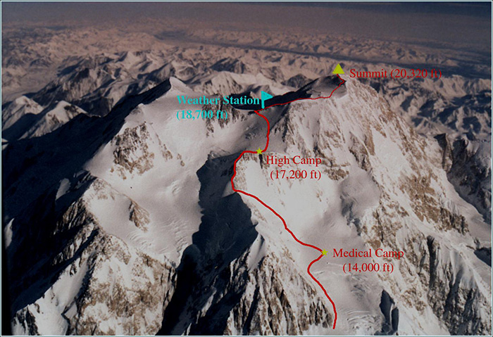
Figure 1. Campsites and weather station location. Image by Tohru Saito
Denali Pass lies north of Archdeacon's Tower (5974 m.a.s.l.) and Denali's main summit (6190 m.a.s.l.), and south of Denali-North Peak (5934 m.a.s.l) – a subsidiary summit of Denali. It forms a west-east oriented col and constitutes the ice divide between the glacier system of the West Buttress to the west and Harper glacier to the east. On the western side of the col, the terrain drops off sharply into a steep, glaciated slope and the glacial plateau of High Camp further below. The drop off to Harper glacier is less pronounced. Figure 1 shows an overview of the Denali summit area and the location of the AWS. The AWS was situated slightly higher than and south of the low point of the pass on an outcrop with exposed rock that allowed for more secure anchoring of the station.
The initial instrument stand installed in June 1990 had a square cross section and was constructed from 4 iron angles joined by crossbars. It was secured with pitons and guy wires, because NPS discouraged the use of bolts. The initial stand was designed and assembled by Mr. Okura, who prioritized compactness and low weight since the stand needed to be carried to the station location. Due to time pressure, the complete station set up was not tested prior to installation and Okura states that “in hindsight, it was not a perfect piece of equipment”. Documentation by the JAC team speculates that the stand was blown over in November 1990. The maintenance expedition of the following year found several guy wires broken, one of the pitons pulled out, and instrumentation destroyed.
Based on the experiences with the first stand construction, a new design with a trapezoidal pyramid shape was subsequently created. The climbing team practiced the assembly of this stand multiple times to guarantee that they would be able to do so under difficult conditions on Denali. Meteorological instrumentation was tested prior to deployment mainly by subjecting sensors to low temperatures in freezers or cold rooms and running field tests. While this ensured that all components were functional, it did not fully simulate the range of conditions on Denali, particularly in terms of wind speed.
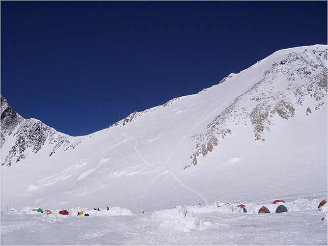
High Camp. Photograph by Tohru Saito.
In 1992, the new stand was successfully installed. After arriving at High Camp, the installation took three days as the team was hampered by cold and windy weather. With permission from NPS, the new stand was secured with bolts. Okura notes that the installation of the second stand was challenging, primarily because of the weight of the equipment. The stand and tools weighed approximately 100kg. Combined with personal gear and food, each of the four team members involved in the installation of the second stand had to move a load of about 60kg. The long poles of the stand construction were cumbersome to carry, which posed an additional challenge. Up to Motorcycle Hill Camp (3350m.a.s.l.), loads were mostly pulled on sleds. From there on, the equipment was carried in multiple trips to the higher camps. In total, the installation team spent 19 days on the mountain, from June 9 until June 28, 1992. The return trip was delayed by 3 days due to an eruption of Mt. Spurr, which impeded air travel in the region. That the installation team consisted of only 4 people highlights the magnitude of their achievement and the limited resources of the Denali Pass AWS project. A comparison with the recent installation of a state-of-the-art AWS network on Mt. Everest is enlightening in this regard. The highest Everest station was installed by a team of 22 people (Matthews et al., 2020).
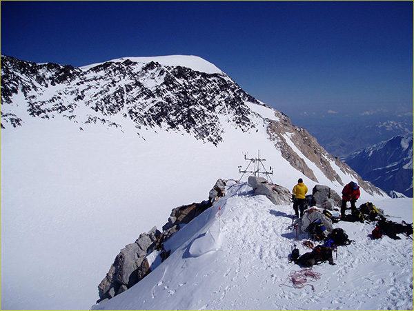
The automatic weather station on Denali. Photograph by Tohru Saito.
Members of maintenance expeditions report that in addition to the effects of altitude and complications inherent to the route (e.g. crevasses, breaking trail in deep snow), the main practical problems encountered when working on the station were the wind and cold, which made it challenging to handle smaller pieces of equipment, such as U-bolts, even on generally favorable days. In the later years of AWS operation, it was sometimes possible to transport equipment on NPS resupply flights by helicopter to Medical Camp. Aside from issues related to mountain travel and equipment, records from organizing UAF team members also note significant difficulties in obtaining continued funding for the AWS upkeep and the annual maintenance expeditions.
The 2007 expedition found that the instrument stand had collapsed because the supporting poles had bent and all antenna cables had broken. Attempts to repair the station in 2008 were prevented by severe weather and the project was subsequently abandoned.
More details on the data available from the Denali weather stations will be published in Part II, so stay tuned! For a longer, more in depth version of the article, see Hartl 2020(b)
References
Frost, R. L. (1934). A climatological review of the Alaskan-Yukon Plateau. Monthly Weather Review, 62(8), 269-278.
Hardy, D.R., Vuille, M., Braun, C., Keimig, F. and Bradley, R.S. (1998). Annual and daily meteorological cycles at high altitude on a tropical mountain. Bulletin of the American Meteorological Society, 79(9), pp.1899-1914.
Hartl, L., Stuefer, M. & Saito, T. (2020a). The Mountain Weather and Climate of Denali, Alaska—An Overview. Journal of Applied Meteorology and Climatology, 59(4), 621-636.
Hartl, L., Stuefer, M., Saito, T. & Okura, Y. (2020b). History and Data Records of the Automatic Weather Station on Denali Pass (5715 m), 1990–2007. Journal of Applied Meteorology and Climatology, 59(12), 2113-2127. https://doi.org/10.1175/JAMC-D-20-0082.1
Matthews, T., Perry, L.B., Koch, I., Aryal, D., Khadka, A., Shrestha, D., Abernathy, K., Elmore, A.C., Seimon, A., Tait, A. and Elvin, S., (2020). Going to Extremes: Installing the World’s Highest Weather Stations on Mount Everest. Bulletin of the American Meteorological Society.
Moore, G. W. K., & Semple, J. L. (2011). Freezing and frostbite on Mount Everest: new insights into wind chill and freezing times at extreme altitude. High Altitude Medicine & Biology, 12(3), 271-275.
Osterberg, E.C., Winski, D.A., Kreutz, K.J., Wake, C.P., Ferris, D.G., Campbell, S., Introne, D., Handley, M. and Birkel, S. (2017). The 1200 year composite ice core record of Aleutian Low intensification. Geophysical Research Letters, 44(14), pp.7447-7454.
Saylor, P.L., Osterberg, E.C., Kreutz, K.J., Wake, C.P. and Winski, D. (2014). December. A Storm-by-Storm Analysis of Alpine and Regional Precipitation Dynamics at the Mount Hunter Ice Core Site, Denali National Park, Central Alaska Range. In AGU Fall Meeting Abstracts.
Washburn, B. (1952). Mount McKinley Weather Experiences. Weatherwise, 5(1), 3-7.
Winski, D., Osterberg, E., Kreutz, K., Wake, C., Ferris, D., Campbell, S., Baum, M., Bailey, A., Birkel, S., Introne, D. and Handley, M., (2018). A 400?year ice core melt layer record of summertime warming in the Alaska Range. Journal of Geophysical Research: Atmospheres, 123(7), pp.3594-3611.
Young, J. C., Arendt, A., Hock, R., & Pettit, E. (2018). The challenge of monitoring glaciers with extreme altitudinal range: mass-balance reconstruction for Kahiltna Glacier, Alaska. Journal of Glaciology, 64(243), 75-88.
This article has been written and adapted specifically for the AMS Weather Band. A longer version of the article can be found at: https://doi.org/10.1175/JAMC-D-20-0082.1 Copyright remains with the AMS.
