Atmospheric Studies from a Moving Weather Observatory
- By Vincent Schaefer
- Feb 8, 2021
Vincent Schaefer's 1955 study on changes in atmospheric conditions between the base of a mountain and its peak was only one small facet of Project Skyfire. Originally aimed at reducing lightning caused fires in timber forests in the western United States, this project created a number of fascinating projects, including Schaefer's extensive research into cloud seeding.
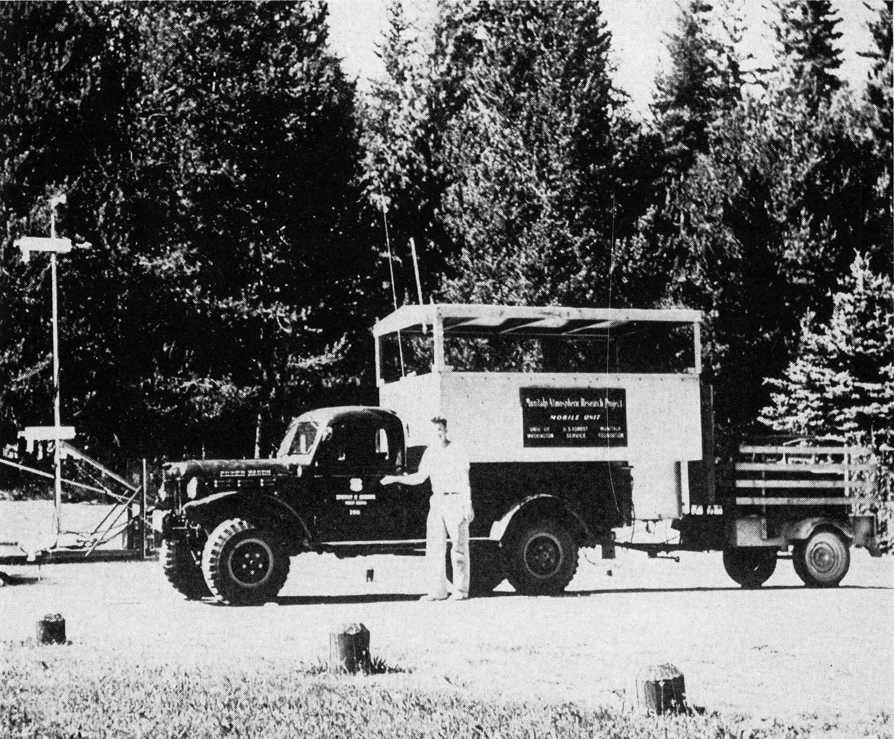
The changes which occur in the air from the base to the summit of a forested mountain throughout the day and night were measured with a moving vehicle during the summer of 1955 as part of the Project Skyfire research program. This was accomplished by the use of the mobile weather observatory developed for the Munitalp Foundation by the Department of Meteorology of the University of Washington. This mobile unit is mounted on the bed of a powerful motor vehicle owned by the U.S. Forest Service and supplied by its Fire Research Laboratory group, which participated in the studies. An outrigger mast 12 feet high mounted on a frame projecting about 6 feet ahead of the cab carried the temperature and dew point sensing elements, which were connected to a multichannel recorder mounted in the mobile observatory. The mobile observatory is shown above.
A 5 kw, 60 cycle, 110 v gasoline motor driven generator set mounted on a trailer is hauled along behind, thus making it possible to obtain continuous observations while the unit moved up and down the mountain roads at speeds up to 10 miles per hour with an average of 5-6 mph during the climbing period.
Studies of the temperature and moisture on mountain slopes at several attitudes and altitudes have been conducted in the past by personnel connected with the Priest River Experiment Station of the Forest Service. These studies utilized four sets of matched stations located in cleared areas on north and south facing slopes extending from the base to the summit of Gisborne Mountain. A network of dirt roads extend to all levels of this mountain and provide easy access to its summit. The summit of Gisborne Mountain is a rocky ridge projecting westward from a long ridge, which runs north and south and is reached by two long sloping east-west ridges that form the sides of a huge amphitheater. The forest on this mountain consists of a pine, larch, cedar, hemlock and fir complex mostly of virgin stand. Benton Creek, a small spring-fed stream, drains the deep valley between the North and South Ridges. The access roads leading to the ridges follow up the Benton Creek valley and then ascend the ridges with a series of switchbacks.
A round trip from base to summit to base required from 228 to 267 minutes. Runs were made during the morning, mid-day, afternoon, late evening and midnight periods. Trips were made in a clockwise direction with the observatory climbing the north ridge and descending the south ridge. This served to indicate the similarity of the general features of the forested mountain slopes with respect to the altitude control of the temperature and moisture, but at the same time disclosed extremely interesting local effects of exposure and topographic features.
Fifteen stations were located along the mountain roads. Eleven of these were positioned at 500 foot altitude intervals, while others were at the base (2400 feet), summit (5400 feet), upper Canyon Creek (4250 feet), and north slope of the Transect (3880 feet). At these fifteen stations the observatory was stopped for periods ranging from three to ten minutes or more. In this manner data were obtained for comparison with the records made while the observatory was moving. The records of temperature and moisture were obtained with Thermohms and Dewcels located on the mast as seen in the diagram below.
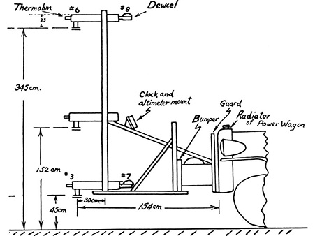
The Leeds & Northrop Speedomax Recorder used to obtain these records was set up to utilize 8 channels and completed a cycle in 32 seconds. The lag coefficient for the Thermohms, defined as the time for the sensing element to reach a value of 1/e, is 84 seconds. Since there were no sudden temperature changes during the trips, it is believed that the instrumental lags do not affect the records to any appreciable degree.
Four observers worked together in securing the data obtained during the exploratory runs which are discussed in this paper. Most of the data secured was obtained automatically so that it should be possible to obtain more than 90 percent of the essential records with only the driver of the vehicle in attendance. Additional notes and all manual and visual operations which were performed during the mountain runs, such as making ice nuclei counts, could be done by a second observer. If runs lasting for 24 hours or more are indicated, two groups should alternate in handling the observations and operation of the mobile unit.
Extraction of Data from the Records
During a round trip up and down the mountain during a 4 hour period with measurements being made of 8 different temperature and moisture conditions, 3600 separate observations are available for study. These are contained on a strip of paper 6 feet long and 10 inches wide. The record consists of 8 different colored, numbered dots, which may be read to about a tenth of a degree Fahrenheit. Each record presents a good visual graph of the temperature and moisture regime of the observation runs. It is obviously impossible to present all of the points on the figures prepared for this paper. Consequently, the figures show the average of three to five separate points obtained while the mobile unit was stopped for a few minutes at the 16 separate stations established along the mountain roads. Since the temperature and moisture values included in the figures are from sensing elements ventilated by small air blowers, no difference in absolute value is noted between the measurements made at a specific spot at a particular time whether the observatory had stopped or was moving. However, to make direct comparisons of the conditions existing during the day and night, the values given in the figures were obtained at identical locations.
Photographic Record of Survey Run
By mounting a time lapse movie camera at the front end of the mobile unit above the recording instruments, a visual record of the terrain, exposure and general features of the surrounding area is automatically recorded. A clock, altimeter and information sheet is also photographed on the lower part of each picture. A time interval between exposures of 2 seconds with the unit travelling 10 miles per hour results in an adequate record. The resulting movie when projected at normal speed presents an excellent visual impression of the area explored by the mobile unit, the amount of sunshine and shade, the type of vegetation, etc. Single frames may be enlarged for illustrative purposes.
Atmospheric Conditions During Exploratory Runs
The Gisborne Mountain runs commenced on the afternoon of August 23, 1955. The day was cloudless, warm and was an excellent example of the type of weather that frequently occurs during the summer in the mountains of northern and central Idaho. August 23rd was the 24th consecutive day without rain. The previous month had been unusually wet, so that fire danger on the heavily forested slopes was only beginning to show high values.
Upon the completion of the first round trip it was decided to make another run about midnight and then continue on the following day, making as many runs as possible to observe the changes that might occur throughout the day and night. August 24th exhibited the same type of cloudless sky. Toward sunset, however, a stream of typical high level clouds of the type associated with a jet stream was observed coming in rapidly from the southwest. That night the mobile unit was used to study the localized movement of air in the Benton Creek Valley. This was done by placing a silver iodide generator in the upper part of the valley at the edge of the creek. Using a cold chamber installed in the observatory, the concentration of ice crystal nuclei in the valley and mountain slope air produced by the silver iodide particles were also measured as the mobile unit was driven up and down the steep slopes of the mountainside.
By early morning a light rain was falling from a solid overcast. A morning run was made from base to summit, the round trip occurring from 0816 to 1149. This run was completed shortly before the rain ended and was followed by rapid clearing with cloudless skies by early afternoon.
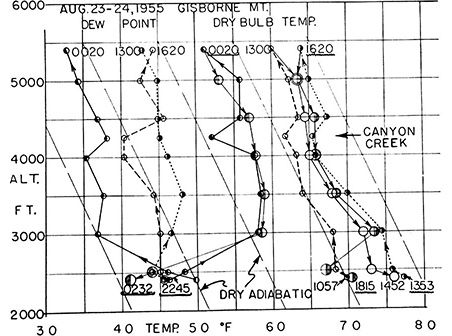
Figure 1. Some variations in moisture and temperature during midnight, midday and afternoon survey runs on Gisborne Mt.
Results of the Base to Summit Runs
The advantage of using a mobile unit for studying the dynamic features of the microclimate of a topographic structure like a mountain side is illustrated by Figure 1. This shows the striking changes in moisture and temperature of the air 3 1/2 meters above the ground, which took place on a forested mountain during a 24 hour period. The greatest contrast, as might be expected, is found between the midnight and midday runs. The very strong nighttime inversion of 14° F in 500 feet at the valley bottom changes to a dry adiabatic lapse rate by early afternoon of the same day.
A similar striking feature is the effect on the local temperature of a small stream valley along the upper reaches of the mountain. Canyon Creek, a small spring-fed mountain stream, has its source in a region of giant cedars. The forest is typical of a mature virgin stand having little underbrush. With its northern exposure, a cold drainage wind is noticeable even during the middle of the day. This again was most pronounced about midnight when the temperature was 5° F colder than stations at altitudes 250 ft above and below the stream.
To a lesser degree, but still noticeable, was the drainage wind effect along the south ridge at the mountain level between 4500 and 4000 feet. This valley is not as well formed at this altitude. It is likely that a survey run along the Center Ridge road would disclose an effect as sharply defined as that found at Canyon Creek, since much of the cold air flowing down the lower valley of Benton Creek and spreading across the flats along the Priest River comes from this region.
The differences in moisture and temperature observed during the day and night while ascending the North Ridge and descending the South Ridge are seen to be quite large. The values for dew point and temperature were obtained at a height of 1/2 and 3 1/2 meters and represent the average of three to five observations recorded while the mobile unit was halted at specific altitude stations along the mountain and valley roads. The differences which can be noted on a particular run up and down the mountain are due partly to the tendency for the ascent route to have a northern exposure and the descent route to have a southern exposure, plus the secular change caused by the passage of time. This latter effect is best seen by comparing the values for Stations 1 and 2 at the start and finish of each run.
It can be noted in the data that at Station 1 at the start and end of the night run the dew point values are higher than the dry bulb temperature. This indication of a considerable amount of supersaturation is quite likely to be real. This region possesses the lowest condensation nuclei counts thus far measured in the United States. Under these conditions a fog immediately forms when condensation nuclei are introduced into the air.
Diurnal Fluctuations in Dew Point and Temperature on Gisborne Mountain
Perhaps the most interesting feature uncovered by the study are the large fluctuations in moisture which occur during the 24 hour period. These are probably produced by the evapotranspiration regime of the living forest and to a lesser degree by evaporation from springs, seepages and the open streams on the mountain sides. The effect of convective air movements during the day and drainage winds at night dominate the temperature profiles. The onset of air drainage down the mountain sides begins by mid-afternoon and is well established at the lower levels by 1800, even on the southern and western exposures. On slopes not heated by the sun some air drainage occurs most of the time. This general effect is probably quite important in the transportation of moisture supplies to the lower levels of a mountain. This phenomenon tends to decrease the humidity on the upper levels of the mountain, increase the humidity at the lower reaches of the mountain, and in particular causes the heavy dews in the valley bottoms.
The movement of the drainage winds was particularly well illustrated during the mountain runs by the motion of road dust, especially in the area of the switch backs. In the region between Stations 15 and 2 a large, clear-cut area was oriented so that by late afternoon a portion was in full sunshine and the remainder in shadow. Dust from the road would move upward along the heated portion and flow downward in the shadow covered region. Within a few minutes after a region was covered by shadow, air drainage dominated the flow patterns.
Occurrence of the Thermal Belt
The so-called "thermal belt" studied by earlier investigators on Gisborne Mountain (then called Looking Glass) is strikingly confirmed by the mobile unit operations. The sharp break in temperature and change in moisture content, which takes place in late afternoon and continues until mid-morning of the following day, is found to have its base at about the 3000 foot level on both ridges of the mountain. The high moisture content in the air of the valley bottoms, which accounts for the heavy nocturnal dews, and the cold air of the mountain summits caused by the efficient radiative cooling of the open grassy slopes in that region mark the lower and upper boundaries of this thermal belt. It is this mid-region of the mountainside, typified by being both relatively warmer and drier than the valley and the mountain summit, which dominates the fire danger pattern during dry periods. It is also the ridges in this thermal belt area which are so often likely to develop lightning fires, because of their extensive areas, effective exposure and seasoned fuels.
Studies of the Stability of the Air in a Forest
The shift within the forest from strong, stable inversion to superadiabatic lapse rate during a 24 hour period is another striking feature disclosed by this study as illustrated by Figure 2. The maximum differences of both stable and unstable conditions were recorded along the South Ridge Road.
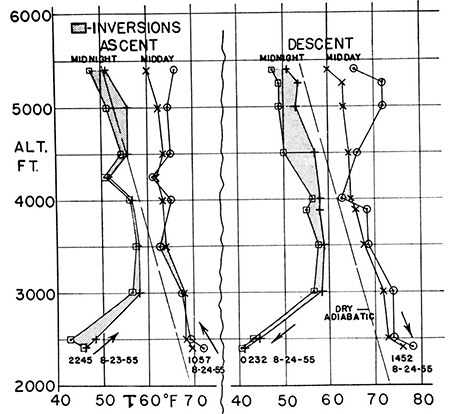
Figure 2. The intensity and degree of air stability on Gisborne Mt. during the middle of the day and night.
An inversion averaging 1.3° C per meter in the air between 1/2 and 3 1/2 meters above the ground was noted at about 0100 at Station 11, elevation 4500 feet in a heavily forested region with a very steep slope with western exposure near the source of Benton Creek.
The opposite extreme, a superadiabatic lapse rate of nearly 1.6° C per meter measured in the same manner was found at about 1330 the following day at Station 10, elevation 5000 feet, at the upper edge of a heavily cut, steep, south-facing slope. During this measurement, which was made in full sunshine, an upslope breeze of 4 mph from the south was observed. At Station 11, elevation 4500 feet, only 0.3 mile beyond but in the heavily forested region the air was still unstable but its value had decreased to 0.4° C per meter. At this location the air movement was still upslope and was 3 1/2 mph from the west. It will be remembered that Station 11 is the point where the maximum inversion had been noted only 13 hours before! Of equal interest is the fact that the only stable air found during the descent of the South Ridge between 1237 and 1452 on August 24 was at the adjoining Station 12, elevation 4000 feet, where an up-slope breeze of 2 mph NW was noted.
The Value of a Mobile Atmospheric Observatory
The importance of detailed understanding of the microclimate of a topographic feature such as a forested mountain is only now being realized. Of the recent investigators, Thornthwaite has most clearly emphasized the need for obtaining such information, although Landsberg and others have stressed the value of properly understanding the local climate for the most effective multipurpose usage of land and topography. Kaplan has recently stressed the need for utilizing such data in numerical forecasting.
By effectively using the technique described in this paper, a means is available for making a rapid survey of pertinent climatological factors that may be used to produce a dynamic picture of the pertinent meteorological features of a localized region. Such a survey quickly locates the regions most sensitive to change so that more detailed studies may be initiated without delay. The method is not limited to the survey of a forested mountain.
A series of 24-hour runs not described in this paper were made during the summer of 1955 at several different types of locations. These included an airport surrounded by distant mountains, a grassy knoll on a mountainside and the edge of a meandering river in a forested valley. All show extremely interesting features, some common to all, others quite different. It is anticipated that our Mobile Unit will be used during the next several years in conducting topoclimatological surveys, using the techniques devised during the Gisborne Mountain runs. Among the subjects which are likely objects for study are: (1) the temperature-moisture relationships of a deforested mountain; (2) the middle of the day conditions which lead to the whirlwind formation of thermals; (3) the temperature-moisture relationships of a cloud-breeding area; (4) the moisture budget of a desert and semi-desert region and (5) special microclimatological surveys of forested and agricultural areas possessing unusual or unique properties such as blight or insect resistance or susceptibility, vegetative growth, etc. Just as the airplane and glider have been found to be highly useful probes for studying certain large scale three-dimensional features of the atmosphere, the mobile atmospheric laboratory will have value in delineating microclimates in three dimensions close to the ground.
