A Day in the Life of Stratocumulus
- By Ted Best
- Apr 9, 2021
Perhaps one of the most important yet unappealing cloud types is stratocumulus. Although they create overcast skies that impose a sense of gloom, they also serve an important function in the heat balance of the earth. This cloud type covers more of the earth’s surface than any other, at approximately 20% on an average annual basis. Small reductions or increases in its coverage can cause changes on the same order as greenhouse gases (Wood 2012). In this case study, I will connect observation and theory to better appreciate and understand this underrated cloud type. In so doing, it will illustrate the dynamic nature of the atmosphere.
Structure and Dynamics
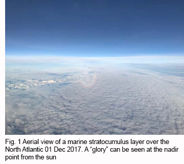 Stratocumulus clouds are layer clouds that form at the top of the planetary boundary layer, sometimes referred to as the stratocumulus-topped boundary layer (STBL). These clouds occur in great sheets where cold air flows over warmer oceans and a stable layer inhibits vertical motion. Figure 1 shows an example of marine stratocumulus over the north Atlantic. Marine stratocumuli are important because of their large coverage. They occur over an average 23% of the ocean surface (Wood 2012). But they are not the only example of the far-reaching nature of these clouds.
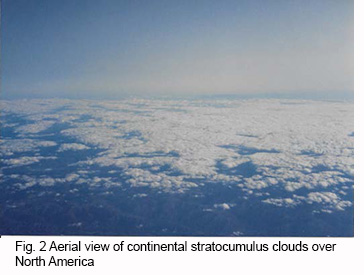 Continental stratocumuli also cover significant areas over land. They may occur in limited regions on the western side of midlatitude cyclones (Field and Wood 2007) where cold air advection dominates (Mechem et al. 2010). Figure 2 shows an example of continental stratocumulus clouds over North America with large breaks in the foreground.
There are numerous dynamics involved in the life cycle of stratocumulus clouds, too many for the scope of this article, but many excellent references cover the mechanisms in detail. Two of these include Stratocumulus Clouds by Robert Wood, and Cloud Dynamics, 2nd Edition by Robert Houze Jr. 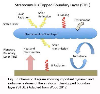
Figure 3 shows a schematic representation of some of the important dynamic and radiative forces giving rise to the formation, maintenance, and decay of stratocumuli. A stable layer caps the stratocumulus topped boundary layer, or STBL, and suppresses deep vertical convection. With heat and moisture flux from near the surface, moist plumes cool adiabatically upward to a lifting condensation level where cloud elements form and fill in to form a stratocumulus cloud layer. Dynamic and radiative effects act on the cloud layer to produce cumuliform textures. Cooling by infrared (IR) radiation at the cloud top causes convection within the layer. Entrainment from the overlying stable layer acts to dry and change the STBL over time and may lead to decay of the cloud layer. The solar reflectance of stratocumuli together with their abundance produces a significant effect on solar radiation that can reach the earth’s surface, the radiative flux change (Chen et al. 2000).
Alberta Clipper Stratocumulus Clouds - The Day Begins
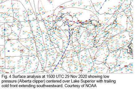 This day is in late November at a time when Alberta clippers are on the increase, reaching an annual average maximum in December and January (Thomas and Martin 2007). Alberta clippers are fast-moving low pressure systems that originate in western Canada. Cold air advection behind the cold front in these systems provides an ideal environment for continental stratocumulus clouds, especially early in the boreal winter season when the ground is still relatively warm. The surface analysis in Figure 4 shows the Great Lakes region on 29 Nov 2020, with an Alberta clipper low over Lake Superior and trailing cold front. There is strong cold air advection over central and southern Minnesota behind the front. In this zone, cold air is moving over warmer ground, and conditions are favorable for stratocumulus layer formation.
 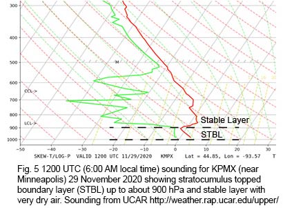 The morning (1200 UTC) KPMX sounding near Minneapolis in Figure 5 shows a well-mixed STBL identifiable by a dry adiabatic lapse rate. This sounding is within about 40 km of the observer’s location. A strong temperature inversion at around 900 hPa formed the stable layer that limited upward convection.
At and above the stable layer, very dry air overlays the STBL. A shallow layer of stratocumuli formed near the line separating the STBL and stable layer, creating an overcast sky condition. 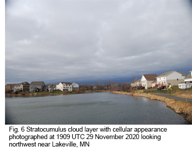
This layer of stratocumulus cloud can be seen at 1909 UTC (1:09 PM local time) in Figure 6. Notice the cellular appearance in the foreground indicative of mild convective overturning in the layer. There is also darkening near the horizon where the cloud layer thickens and very little light is scattered back to the observer’s position. It is important to mention that although the 1200 UTC KPMX sounding provides an approximation for the vertical temperature and moisture profile, it has likely modified by the time the photo in Figure 6 was taken. Evidence for the strong, gusty surface winds can be seen on the water, so turbulence in the boundary layer could reasonably be anticipated.
An Everchanging Sky - The Day Continues
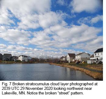 We continue our day in the life with Figure 7 taken at 2039 UTC, about 1.5 hours after Figure 6. By this time, the stratocumulus layer has changed from overcast to broken. Entrainment of dry air from above the layer was likely eroding some of the cloud layer. Some broken “streets” are also noticeable in the cloud layer, especially near the horizon, which suggest a pattern for ascending and descending motions in the boundary layer. In only about 90 minutes, this day in the life has changed character from gloomy overcast to a brighter mood.
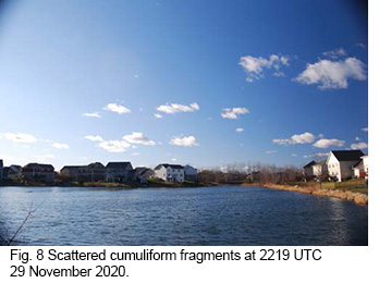 Now that things are looking up, we fast-forward about 2 more hours to 2219 UTC in Figure 8. A few scattered cloud fragments are all that remain. Dry air entrainment and continued mixing have modified the STBL further. Although the strong northwest winds continue, the day has become mostly sunny!
Looking at the 0000 UTC (evening) sounding in Figure 9, and comparing to the morning sounding in Figure 5, we see the deepening of the STBL depth from 900 hPa up to 800 hPa. 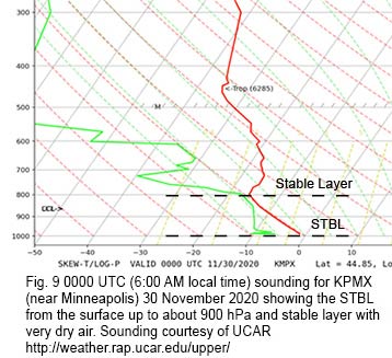 The layer shows a near perfect dry adiabatic lapse rate, and there is still a stable layer above, but entrainment and mixing of the dry air from the stable layer have eroded the clouds and helped to increase the depth of the STBL throughout the day.
At the End of the Day
This day illustrates the dynamic nature of continental stratocumulus clouds and the atmosphere in general. Processes that we cannot see are sometimes observable through the clouds that we watch every day. The STBL is a small part of larger scale weather system, in this case, the Alberta clipper. And at the end of the day, even if stratocumulus clouds bring us a sense of gloom, we can appreciate them for what they are.
References
Chen, T., W.B. Rossow, and Y. Zhang, 2000: Radiative Effects of Cloud Type Variations. J. Climate, 13, 264-286.
Field, P.R., and R. Wood, 2007: Precipitation and Cloud Structure in Midlatitude Cyclones. J. Climate, 20, 233-254.
Houze, R.A., Jr., 2014: Cloud Dynamics 2nd Ed., International Geophysics Series, Vol. 104, Academic Press, 432 pp.
Mechem, D.B., Y.L. Kogan, and D.M. Schultz, 2010: Large-Eddy Observation of Post-Cold-Frontal Continental Stratocumulus. J. Atmos. Sci., 67, 3368-3383.
Thomas, B., and J.E. Martin, 2007: A Synoptic Climatology and Composite Analysis of the Alberta Clipper. Wea. Forecasting, 22, 315-333.
Wood, R., 2012: Stratocumulus Clouds. Mon. Wea. Rev., 140, 2373-2423
