Weather and Death on Mount Everest
- By G.W.K. Moore and John L. Semple
- Jan 15, 2021
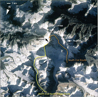
With a height of 8,848 m, Mount Everest is the highest mountain in the world. For over a century, it has been the subject of exploration for both scientific and recreational purposes. This exploration began in earnest with the British expeditions during the early part of the twentieth century. At that time, Nepal was closed to foreigners and so these efforts were focused on finding a route to the summit from the north through Tibet. During the 1921 expedition, a potential route to the summit was identified that is now referred to as the North Col-North Ridge route. It was via this route during the 1924 expedition that Norton attained an altitude of 8,565 m without the use of supplemental oxygen—a record that stood for 54 years until Messner and Habler reached the summit in 1978. Several days after Norton's feat, Mallory and Irvine perished during a summit attempt made with the use of supplemental oxygen (Hemmleb et al. 2001; Venables 2003). To this day, it is still unclear if Mallory and Irvine were able to reach the summit before their deaths. Exploration of Everest continued via this route until the beginning of World War II.
After the war, as a result of turmoil in Tibet and the opening of Nepal to foreigners, the focus of the exploration of Mount Everest shifted to the south and the discovery of a route that followed the large horseshoe shaped cirque or valley known as the Western Cwm, bounded by Nuptse, Lhotse, and Everest to the South Col, and then ultimately to the summit (Venables 2003). This route, known as the South Col route, ascends through the Khumbu Glacier and Kumbu Ice Fall into the Western Cwm, up and across the Lhotse Face to the South Col, and then along the south ridge to the summit of Everest. This route was the one used by Hillary and Norgay (Hillary 2003) in the first successful summit of Mount Everest in May 1953. Although other routes to the summit have been pioneered in the intervening years, these two routes remain the most popular.
Much of the focus of scientific interest in Mount Everest has been on the impact that the low barometric pressure near its summit has on human physiology. These studies have shown that above 7,000 m, climbers are at the limits of their endurance and are exposed to significant risks associated with the reduced amount of oxygen available for respiration: cold temperatures and high winds.
Perhaps the most dramatic example of these risks occurred in early May 1996 when a storm engulfed Mount Everest, trapping a number of climbers on its exposed upper slopes and ultimately resulting in eight deaths. This event and the ensuing tragedy received international attention at the time and became the subject of a number of books, including Into Thin Air (Krakauer 1999) and others (Boukreev and DeWalt 1999; Breashears 1999; Dickinson 1999), as well as figuring prominently in the movie "Everest" (MacGillvray and Breashears 1998).
The Tragedy of May 1996 or the Into Thin Air Storm
On the evening of 9 May 1996, a large number of climbers were poised to make summit attempts from camp IV situated at 8,000 m on the South Col of Mount Everest. High winds had persisted throughout the day and the possibility of summitting appeared low. The winds died down during the evening and the conventional wisdom was that they would remain calm for a period of time. As a result, the decision was made to attempt to summit and the climbers left around 2000 LT on the 9th for the 18-24-h round-trip to the summit. During the afternoon of 10 May, an intense storm with wind speeds estimated to be in excess of 30 meters per second, heavy snowfall, and falling temperatures engulfed Mount Everest, trapping over 20 climbers on the exposed upper sections of the mountain above the South Col. The unfavorable weather appears to have abated overnight, although winds remained high near the summit. There was, however, a reintensification during the day on the 11th. Throughout this period, a number of heroic attempts were undertaken to rescue the trapped climbers, but they were hampered by the high winds and the harsh weather. Tragically, five of the climbers could not be rescued and perished.
By the afternoon of the 11th, most of the people on the upper slopes of Mount Everest were sheltered in tents at the South Col. In this regard, the impact of the weather on the 11th was not as catastrophic as that on the 10th. Supplemental oxygen was however in short supply and there is evidence that even those that had taken shelter were suffering from the lack of oxygen that may have been exacerbated by the unusually low barometric pressure (see below). A number of climbing parties who were attempting to summit along the North Col-North Ridge route were also trapped by the storm and three more people died.
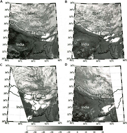
Although the harsh weather abated after the 11th, winds near the summit remained high for the next 5 days, hindering attempts to summit. Satellite images from 9 May 1996 (Fig A) show widespread and scattered convection over the Tibetan Plateau with India being, for the most part, cloud free. The distinct boundary between the cloud-covered and cloud-free areas lies along the Himalayas (Hirose and Nakamura 2005). 
The images from 10 and 11 May (Figs. B and C), the period of the Into Thin Air storm, are dramatically different. They show the presence of deep convection in the immediate vicinity of Mount Everest (marked by a cross on the Nepal/Tibet border). The outbreak of convection on the 11th appears more organized, with the clouds tops higher than those on the 10th. Indeed, the convection in the vicinity of Mount Everest on the 11th has the characteristic circular cloud shield or anvil that is often associated with organized collections of thunderstorms known as mesoscale convective complexes. On the 12th (D), one has a situation similar to the 9th, with widespread but scattered and shallow convection over the plateau with no evidence of deep convective activity in the vicinity of Mount Everest.
This outbreak of high impact weather resulted in the largest number of fatalities (8) to occur near the summit of Everest during a single event. In the ensuing years, a passionate and wide-ranging debate has been ongoing in an attempt to understand the factors that contributed to this tragedy (Boukreev and DeWalt 1999; Breashears 1999; Dickinson 1999; Krakauer 1999; Roberto 2002; Mangione 2003; Kayes 2004). Curiously absent has been a quantitative discussion of the meteorological conditions that gave rise to this storm and the storm's impact on the climbers' physiology.
Learning More About Weather Conditions on Everest
Motivated by the 1996 tragedy on Mount Everest, the Media Laboratory at the Massachusetts Institute of Technology (MIT) developed a portable sensor package to monitor weather conditions on Mount Everest (Lau 1998). One such portable weather station was deployed at the South Col of Mount Everest and operated from May to September 1998. Moore and Semple (2004) performed an analysis of these data and compared the observed temperatures and pressures to both the National Centers for Environmental Prediction (NCEP)-National Center for Atmospheric Research (NCAR) reanalysis (Kalnay et al. 1996) and the European Centre for Medium Range Forecasts (ECMWF) Re-Analyses (ERA-40) (Simmons and Gibson 2000). They found that the reanalyses were able to capture much of the day-to-day variability in the pressure and, to a lesser extent, the temperature at the South Col of Mount Everest.
There is one particularly interesting high-impact weather event that was captured in the South Col meteorological observations in May 1998. High winds and heavy snowfall were reported, and it resulted in a major impact to operations on Mount Everest. Moore and Semple (2004) showed that this event was associated with the passage of an upper-tropospheric jet streak, an elongated region of high wind speed embedded within the subtropical jet stream, near Mount Everest. They also showed that this event from 1998 was associated with a maximum in the time series of the Total Ozone Mapping Spectrophotometer (TOMS) total column ozone over Mount Everest and furthermore suggested that ozone-rich stratospheric air may have been present near the summit during this event.
These results suggest that the summit of Mount Everest resides in the dynamically interesting but relatively unexplored region of the atmosphere known as the "middleworld" (Hoskins 1991), where the stratosphere and troposphere are in direct communication. During the 1998 high-impact weather event, there was a relatively large discrepancy between the observed pressure at the South Col and the extracted values from the NCEP-NCAR and ERA-40 reanalyses. Through the analysis of satellite imagery of the event, Moore and Semple (2004) argued that this discrepancy was the result of an outbreak of convection in the vicinity of Mount Everest that was not resolved in the reanalyses. With regard to the initiation of this convection, they argued that it was triggered by ageostrophic circulation associated with the presence of the jet streak in the vicinity of Mount Everest (Uccellini and Johnson 1979; Keyser and Shapiro 1986). This 2004 analysis of the South Col observations provides something of a roadmap for investigating the weather associated with the May 1996 Into Thin Air tragedy and its impact on the people who were trapped near the summit of Mount Everest.
Want more storm specifics? Stay tuned for Part II and an indepth analysis of the 1996 or Into Thin Air Storm
NB: This work has been edited and adapted specifically for the AMS Weather Band. Any omissions and errors should be attributed to AMS Staff.
