Storm Chasing Through the Eyes of Maestros
- By Amber Liggett and Dr Ashton Robinson Cook
- Apr 13, 2023
Amber Liggett and Dr. Ashton Robinson Cook
Spring 2023 severe weather season is well underway as we’ve already had deadly storms in the Midwest and Southern U.S. in March and early April. Understanding that this time of year is also popular for storm chasing, Meteorologists Amber Liggett and Dr. Ashton Robinson Cook share their experiences, lessons learned, and the science of storm chasing for those who have ever had an interest in and/or participate in storm chasing.
Why storm chasing?
Amber:
“I have two experiences storm chasing firsthand; both times were in eastern Colorado and both were exhilarating experiences. My first chase was in May 2016. I went with experienced chasers and saw a rain-wrapped tornado. They had proper equipment including a laptop with wifi to view radar, phone chargers, water, snacks, and comfortable clothing to be out in rainy, windy weather. We traveled in a vehicle that has been used to chase before – we didn’t have to worry about hail damaging the car.
My second experience was in May 2018. This one was more eventful and produced great views. It started off with me and a peer meteorologist chasing with the peer’s alma mater university’s storm chasing trip. While with the larger group, we saw two landspouts.
.jpg)
Image: Landspouts in eastern Colorado on May 28, 2018
Credit: Amber Liggett
After that, we decided to part ways and continue chasing on our own before heading back to our place. That is when we had to rely solely on the skills that we each developed during previous chases. In eastern Colorado, it is very rural and there was no cell service. There was no working GPS and we couldn’t access the radar on our phones. We had to rely on our knowledge of mesoscale meteorology (e.g. tornadoes, thunderstorms, etc.) to determine which way to continue with our chase. I was also able to use my knowledge of gridded roads in the region to direct us back to the highway. We successfully escaped the path of the storm, but saw many people who didn’t and decided to pull their cars to the side of the road and wait under overpasses which is a huge no-no.”
Dr. Cook:
“My fascination with storms (tornadoes in particular) stemmed from experiences with them as a child (including being directly hit by one!). Most of my earlier interactions with tornadoes occurred via radar observations in either an operational warning environment or via watching live coverage from local media. Moving to Oklahoma and chasing meant having the increased visibility to see storms from a safe distance due to the flat, mostly treeless terrain. Seeing storms in person allowed for me to relate the features I had observed on radar for many years to the features typically seen around supercells, including banded structures, rotating updrafts, wall clouds, and occasionally direct impact to property. It really enhanced my understanding of severe convection, and hence my ability to forecast and communicate impacts from these incredibly powerful systems.”
Video: Low-precipitation supercell in Okfuskee County, Oklahoma on May 27, 2017 Credit: Ashton Robinson Cook
.png)
Image: Radar velocity image captured a few minutes after the observed supercell/timelapse in Okfuskee County, Oklahoma - 5/27/2017
Credit: RadarScope
Lessons Learned
Amber:
“Throughout each experience, I learned new, useful lessons. The most important lesson is that it is essential to prepare for the chase and have the proper equipment. Unless you have a vehicle with wifi or a mobile hotspot, it is unlikely you’ll have consistent cell service to utilize radar and maps on your cell phone throughout the chase – as was my case. It is best practice to come prepared with proper equipment including a handheld map, a mobile hotspot for radar use, and car chargers.”
Oftentimes, chases will lead you to remote locations without easy access to fuel, food or water, so make sure you start off with a full tank of gas and fill up again before you reach remote locations without any more fuel. You want to dress for the weather - while it’s typically warm and muggy on days with a chance of severe weather, there’s also a lot of wind which whips debris, rain and hail. Gently used clothes, old shoes, and a jacket are good rules of thumb for clothes. Even if it’s warm out, these tend to be extremely windy, rainy, muddy events which can make them chilly, messy and potentially uncomfortable with hail and other debris. So stay alert and aware of your surroundings.
Additional lessons learned include not parking too close to other chasers as you never know when you’ll need to drive off in a hurry as the weather conditions change. Again, if it’s raining, you don’t want to get stuck in mud and block other vehicles. These are constantly evolving atmospheric conditions and tornadoes are phenomena that are not fully understood by meteorologists. Even seasoned, veteran chasers have been struck by tornadoes in recent years. Keeping a safe distance from areas of rotation is a must.
Science of a Good Chase Day
When planning for a chase and while chasing, you hone forecasting skills. It’s imperative to understand how thunderstorms and tornadoes work; a chaser needs to understand the dynamics and the patterns of these storms to avoid being caught in the storm or being chased by the storm. The increased knowledge and understanding of the behavior of basic weather should include radar and satellites, thunderstorm life cycle, and tornadogenesis, the process by which tornadoes form.
Forecasting for a given chase is not quite like forecasting for broader severe convective threats (i.e., severe hail or damaging wind gusts). Instead, a successful forecast of a chase involves targeting areas containing the best potential for visible tornadoes typically from supercells. This forecast process is typically ‘ingredients-based’ and involves an assessment of combinations of lift, shear, moisture, and instability. But how will these ingredients come together? Too much lift can cause too many storms to form and interact, limiting isolated supercell potential. Too little shear can cause storms to be outflow-dominant and short-lived. Too little instability – or instability that is rooted only at levels above the boundary layer can cause storms to be non-tornadic. Will outflow boundaries or warm fronts (often favorable sources of low-level vorticity) help storms rotate and become efficient tornado producers? Or will surging cold fronts quickly undercut the storms and weaken their updrafts?
Additionally, more practical concerns are also warranted while considering a chase: Is the magnitude of the threat large enough to potentially sacrifice hours on the road or should one just sit out to wait for the next big severe weather threat? Other obligations (work, school, home) may also play into the decision to chase and where to target.
Another consideration: chaser convergence. Will there be too many chasers on a limited number of storms to navigate safely? Is there a secondary (or tertiary) target with large enough tornado potential within reach?
Dr. Cook:
“Too many storms in the Texas Panhandle and northwestern Oklahoma caused a strong outflow boundary to surge southward in the open warm sector, limiting potential for chaseable storms on May 20, 2019 while focusing the target of many chasers to a small area in western Oklahoma. This created immense chaser convergence as one warm-sector supercell actually managed to form a significant tornado.”
Dangerous Scenarios
Supercells have often posed significant risks to storm chasers because of their unpredictability. Oftentimes, long-lived supercells can produce multiple tornadoes when a new mesocyclone forms along the gust front of a parent supercell as seen in the below photo:
.jpg)
Image: Two tornadoes spawned from the Dibble to Goldsby, OK supercell from May 24, 2011. The tornado on the left was weakening, but had produced high-end EF4 damage along its path in McClain County, OK earlier in its life cycle. The tornado on the right and produced EF1 damage just east of the initial tornado.
Credit: Ashton Robinson Cook, Josh Reed, and Brandon Rycroft
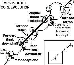
Image: Schematic describing the process of mesocyclone occlusion and handoff.
Credit: National Weather Service Forecast Office in Louisville, KY
This process, also known as a ‘handoff’, can surprise chasers viewing the storm from its inflow region, or near/under its gust front.
Other road hazards can compound already present dangers from the near-storm environment, including distracted driving, wet or muddy roads, and onboard instrumentation (i.e., mobile phones and laptops). Tornadoes are often rain-wrapped, happen at night, and can even move at speeds exceeding 60 mph, sometimes hindering the ability for chasers to successfully and safely navigate away from danger.
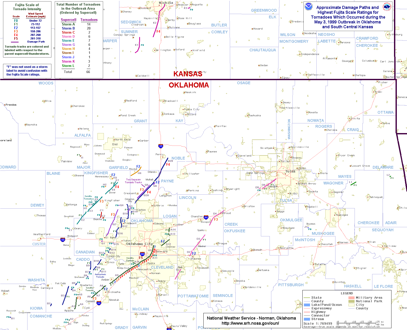
Another hazard that leads to unpredictability in the path of tornadoes are occlusions. This process completely surrounds the tornado with relatively cool outflow from the parent storm, and typically causes a tornado to veer to the left. This example from May 3, 1999 (the Bridge Creek/Moore tornado; pictured in the figure below) features a violent tornado that veers to the left while occluding over Midwest City near Tinker Air Force Base, although the tornado doesn’t necessarily lose strength during its occlusion process. These reporters from KFOR-TV in Oklahoma City had a rather incredible view of the violent tornado as it moved through Moore just south of their position. However, had the occlusion process happened earlier in the tornado’s life cycle, it is possible that the reporters would have had to make critical decisions to escape harm, potentially experiencing direct impact from the tornado by driving east or south, or perhaps experiencing significant hail by driving west (through the ‘hook’) or north (toward the ‘forward flank’). These types of maneuvers have actually proven deadly in the past, as documented by the National Weather Service in Norman, OK.
.png)
Image: Tornado paths and damage ratings during the May 3, 1999 tornado outbreak in central Oklahoma.
Credit: National Weather Service Forecast Office in Norman, Oklahoma (link: bigmap.gif)
Overall, storm chasing is a unique opportunity to experience some of nature’s most powerful weather phenomena. Everyone’s experience is different, but there are common best practices that enhance the safety and success of the experience. By sharing anecdotes and lessons learned from Amber and Dr. Cook, AMS Weather Band hopes to better inform people interested in the science of chasing tornadoes as well as those who partake in the activity.