Lightning Data
- By Chris Vagasky
- Apr 25, 2023

Author Chris Vagasky
Lightning season is getting closer now that we’ve entered the spring months. In fact, a paper published in Monthly Weather Review shows that 64% of the annual cloud-to-ground (CG) lightning occurs in June, July, and August. As this is also when a lot of outdoor recreation like camping, fishing, and outdoor sports take place, awareness of lightning is especially important to keep people safe. One of the best ways to keep safe from lightning is to know where it is so you can end outdoor activities and get inside before it reaches you. So just where does this lightning data come from and how can you access it?
Where does lightning data come from?
When lightning flashes in the sky, it acts like a giant radio antenna that sends electromagnetic waves around the world at the speed of light. With specialized sensors that listen for the electromagnetic waves that lightning produces, lightning detection networks can determine the time and location of the lightning, whether it was in-cloud or cloud-to-ground, and how strong it was.
There are multiple companies that own lightning detection networks across the United States, like Vaisala’s National Lightning Detection Network and Earth Network’s Total Lightning Network. These companies employ scientists and other professionals to develop and maintain their networks to provide high quality lightning data to interested users. Each network detects most of the cloud-to-ground lightning that occurs around the United States with very high accuracy, making the data useful for lightning safety applications.
How can I see the lightning data?
Because private companies own the networks that are used to detect lightning, the data is generally provided on a subscription basis – but that doesn’t mean it’s out of reach. Weather apps often have the option to display lightning locations or give you lightning alerts based on the data from Vaisala or Earth Networks.
RadarScope, for example, shows the location of cloud-to-ground lightning flashes that were detected by the Vaisala National Lightning Detection Network. The Weatherbug app shows the location of lightning and provides alerts based on Earth Networks Total Lightning Network data. Other apps are available and provide similar features. Try different apps to find the one that you like the best.
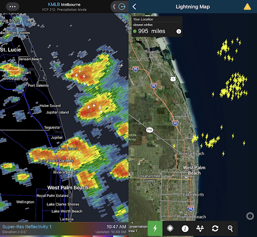
RadarScope (left) and Weatherbug (right) show lightning detected in thunderstorms near West Palm Beach, Florida. The two apps display different types of lightning data, so there are differences in the lightning counts shown.
Staying lightning safe this summer
As thunderstorm season ramps up and more lightning starts occurring, remember some basic lightning safety tips.
- First: There is no safe place outdoors when thunderstorms are in the area.
- Second: When thunder roars, go indoors! See a flash, dash inside!
Lightning injures and kills people who remain outside during thunderstorms every year. When you hear thunder, see lightning nearby, or see lightning data/alerts on your favorite app, it’s time to wrap up outdoor activity and get to your lightning safe place. A lightning safe place is a substantial building that has electrical wiring and plumbing in the walls (not a picnic shelter, gazebo, or pavilion) or a fully enclosed metal vehicle.