Getting Ready for an El Niño Winter: 2023–2024 Outlook
- By Douglas Hilderbrand and Katie Pflaumer
- Nov 14, 2023
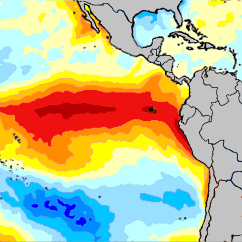
El Nino map
We’re getting set for the first El Niño winter since 2018–19—likely the strongest El Niño in more than a decade. This will be one of the main factors driving global weather patterns this November through January, according to recently released predictions by NOAA’s Climate Prediction Center. Let’s take a look at what’s in store.
The Outlook
This winter will be dominated by the El Niño phase of the El Niño-Southern Oscillation (ENSO) pattern. Supported by continued high sea surface temperatures in the Pacific, El Niño is predicted to continue or strengthen, leading to a strong jet stream to the south of the United States that is likely to bring enhanced moisture and storms to some areas, especially the Southeast. Meanwhile, if you’re in the northern U.S., you may experience a warmer, and possibly drier, winter than you’re used to, another common result of El Niño. Unfortunately, the drought conditions that played a role in this year’s Maui wildfires are also predicted to continue in Hawaii. Drought is also expected to persist in the Southwest and interior regions of the Pacific Northwest.
Temperature: We expect a warmer-than-average winter in most of the northern United States, especially in Alaska, northern New England, and the Pacific Northwest. Temperature trends in the rest of the country are either unclear or likely to be near-normal.
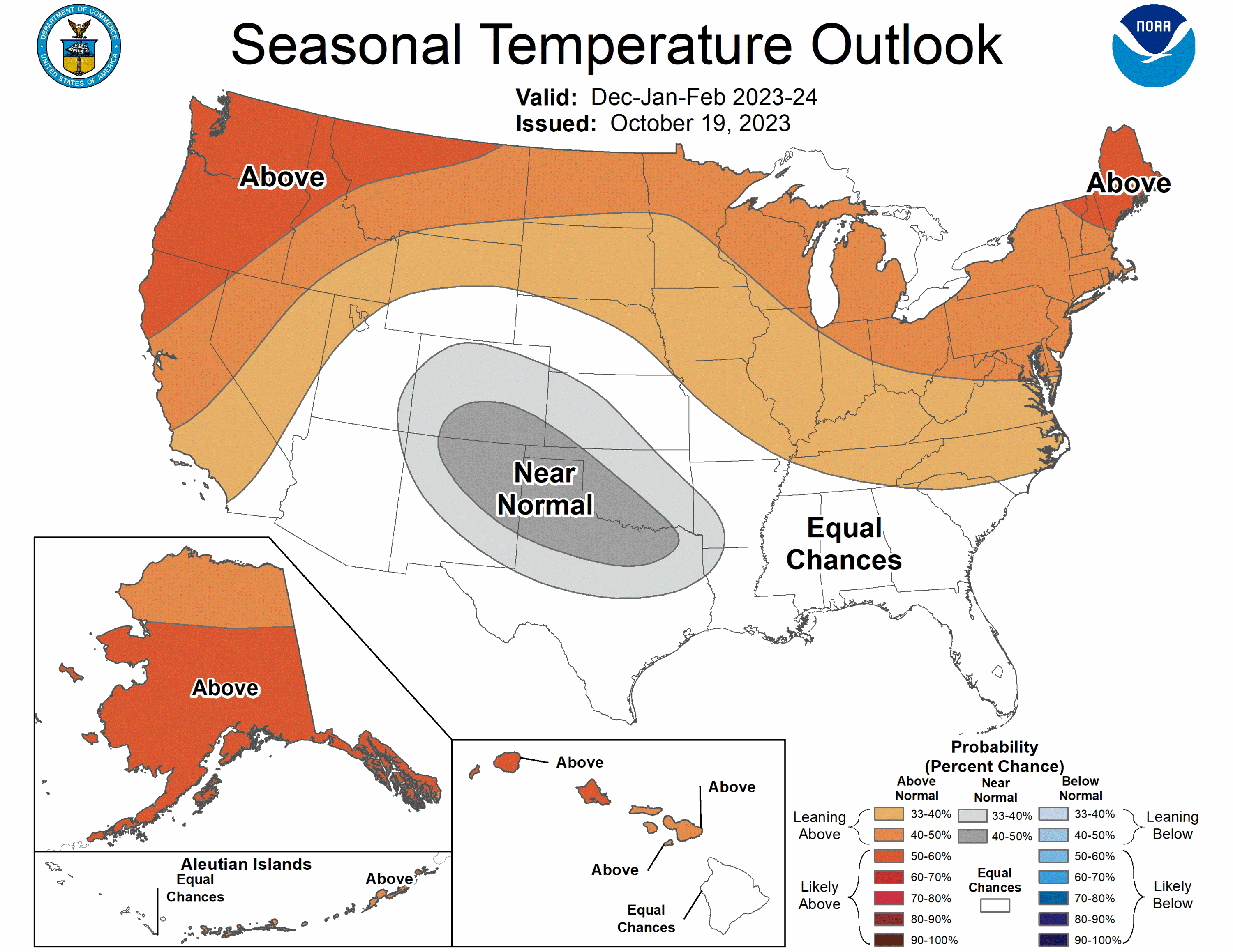
The 2023-2024 U.S. Winter Outlook map for temperature. (Image credit: NOAA)
Precipitation: NOAA predicts a wetter-than-average winter along much of the middle and southern U.S., including parts of the West, the south-central Rockies, the southern Plains, Gulf Coast, Southeast and lower mid-Atlantic. Northern Alaska is also likely to see above average precipitation. Meanwhile, lower-than-average precipitation is expected along parts of the northern contiguous U.S., especially in parts of the northern Rockies and central Great Lakes.
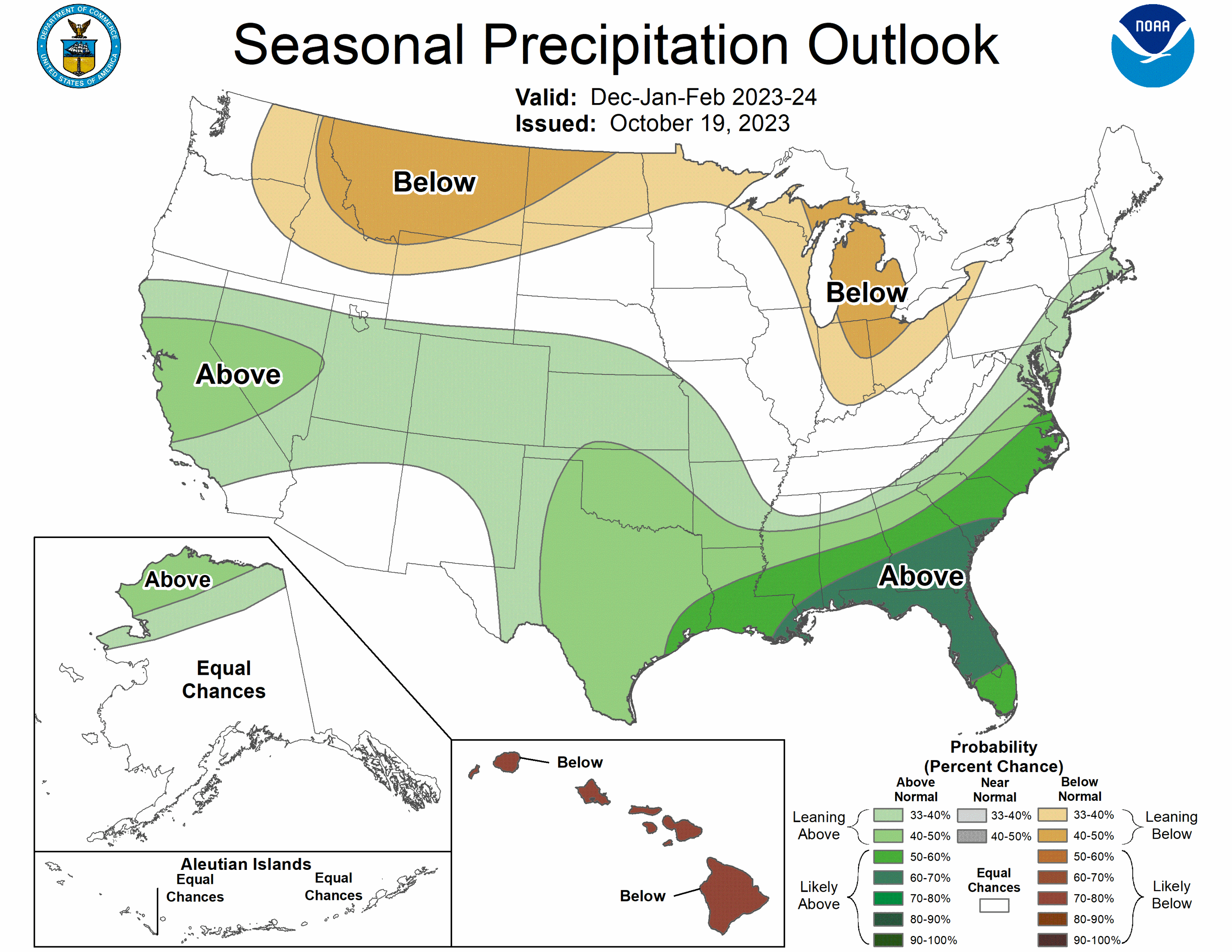
The 2023-2024 U.S. Winter Outlook map for precipitation. (Image credit: NOAA)
Drought: Drought conditions across the Southeast, Gulf Coast, parts of the central U.S., and Texas are predicted to improve or in some areas lift completely due to higher-than-average precipitation this winter. However, drought conditions are expected to persist, develop, or worsen in parts of the northern Great Plains, the northern Rockies, areas of the desert Southwest, Hawaii, and possibly the interior Pacific Northwest.
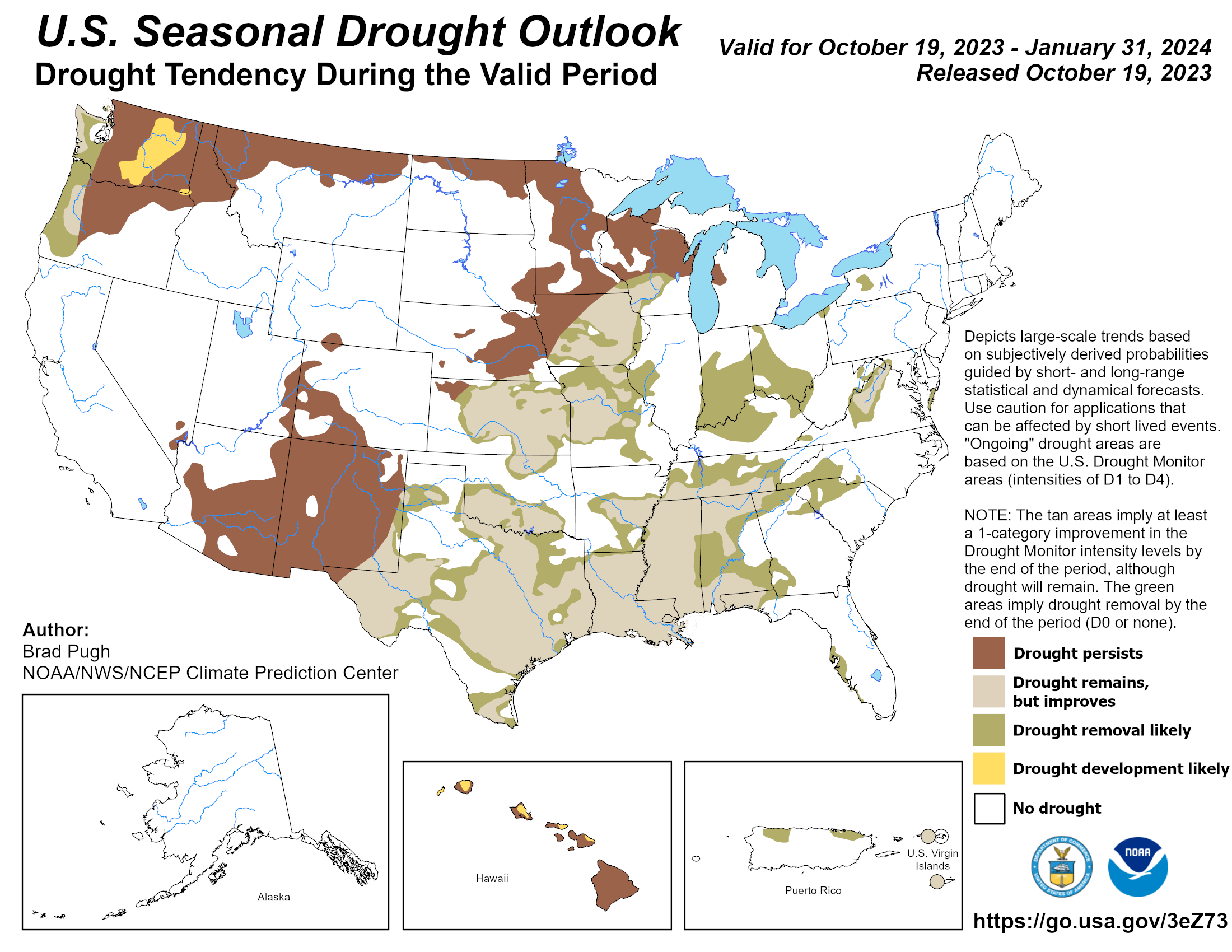
The U.S. Drought Outlook map for November 2023 through January 2024. (Image credit: NOAA)
Takeaways
As we expect a warmer-than-average winter across the northern half of the U.S., it’s important to be clear that there are multiple climate factors at work, not just El Niño. On the one hand, shorter-term patterns like ENSO can have outsize influence on each year’s climate. On the other hand, the background of global warming can mean stronger effects from El Niño and possibly counteract some regional cooling effects that El Niño would usually cause.
Many regions where above-average temperatures are expected will likely also see lower precipitation, and even drought, this winter. Notable exceptions include areas like northern New England, Alaska, and the coastal Pacific Northwest. There are also a few areas (including parts of the Southwest) where NOAA predicts higher-than-average rainfall, yet drought is predicted to persist due to the large precipitation deficit. Meanwhile, the southeastern United States, especially Florida, seems especially likely to have a wetter-than-average winter, including the end of drought in certain areas—while it’s a toss-up as to whether the temperatures will be above or below average.
A word of caution: Keep in mind that NOAA’s seasonal outlooks are based on probabilities over the whole November–January period, combined from several models and many different observations. There can be a great deal of variation in what different models predict.
It’s always possible for weather patterns not to do the most likely thing—and even if they do, it’s almost certain that we’ll see events that don’t fit the pattern. There could be a huge snow or rainfall event in an area where drought is predicted, for example. You can also see in the maps above that the chances of above-average temperatures or precipitation are different in different areas. But overall, on average, these are the patterns we expect to see.
In addition, NOAA’s seasonal outlooks focus on whether rainfall and temperatures are likely to be higher or lower than average. That doesn’t have to mean they’ll be much higher or lower than average.
The forecasts are also likely to be less accurate for dates farther out—some models suggest we’ll see cooler-than-average temperatures in parts of the southern plains, for example, as we move into early 2024.
You can read NOAA’s brief summary of the three-month forecast here or read a longer explanation here.
Let us know whether your winter plays out as predicted: share and discuss your local weather in the Weather Band Community!