Fly Over the Dye
- By AMS Staff
- Aug 22, 2022
PROBLEM
The movement of coastal waters is difficult to track over space and time because of the spatial complexities and variable nature of coastal ecosystems and the difficulty of monitoring water flows over a large area.
SOLUTION
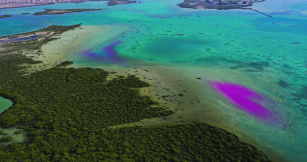
In research conducted last year along the Red Sea coast, scientists utilized unmanned aerial vehicles (UAVs) to track the movement of dye plumes released into the water as the tide ebbed. Two drones continuously traced the plumes by collecting photos every 10 seconds for 80 minutes. UAV flight surveys then collected data as the plumes spread over a larger area. Dye concentration samples collected manually were related to pixel values of the spectral bands and indices of 30 different UAV photos. The photos were taken concurrently with the seawater samples to establish a relationship to be used to map dye concentrations for the duration of the ebbing tide. The resulting data provide insights into the vertical and horizontal movement and dilution of nutrients and other materials in the water column between mangrove, seagrass, and coral reef ecosystems. “With new high-spatial-resolution satellite constellations becoming available and allowing subdaily image collection, satellite-based dye-tracing experiments may be accomplished for much larger areas, with UAV data potentially bridging the gaps between field measurements and satellite image data,” says lead author Kasper Johansen of the King Abdullah University of Science and Technology (KAUST). Runoff in coastal waters contributes to the pollution and degradation of coral reefs and other marine ecosystems, and the study shows that the use of UAVs “offers a more accessible and cost-effective way for regular monitoring of coastal water movement,” according to coauthor Aislinn Dunne of KAUST. The research was published in Scientific Reports.
CAPTION: Unmanned aerial vehicles and dyes were used to monitor the movement of water between habitats along the Red Sea coast. [Photo Credit: 2022 King Abdullah University of Science and Technology]
This content was taken from the Bulletin of the American Meteorological Society (BAMS), the flagship magazine of AMS. View this BAMS parcel and more!