Do Roads Have Weather?
- By William B. Gail
- Aug 31, 2023

William B. Gail
Perhaps you’ve heard the term “road weather”. Maybe you wonder why we need a name for something that seems no more than weather reported at a road location.
There is a good reason. Weather-related road conditions are a substantial contributor to vehicle accidents, so characterizing and predicting those conditions is important. Weather on the road surface can be considerably more complex than what’s happening in the air above. Think about rain falling on a road. For much of the time when it is raining the road weather is simple–a wet road. But how wet? Water drains from the road, so there is generally less water on the road than what has fallen. But how much less? And the road likely can be considered dry for some minutes after the rain starts. How many minutes depends on the rain rate, the road temperature, and more. Once the rain stops, the road may take minutes to hours to dry, with cloud cover and sun angle being big factors. Sounds complex.
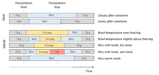
Figure 1. These examples show how evolution of rain or snow on the road surface can be complex, with multiple stages.
Now substitute snow for rain and the complexity multiplies. Snow may melt, accumulate, or even turn to ice, depending on the road temperature. During a snowstorm, a reasonable characterization of the atmospheric weather is possible by knowing only the storm start and stop times and the average snow rate during the storm. For that same storm, characterizing road weather may require knowing 1) how long the road remains dry after the storm starts; 2) whether the falling snow melts, sticks, or blows off; 3) when the snow gets plowed and what treatment is applied; 4) how long it takes for any snow to melt after the storm stops; and 5) how long it takes melted snow to dry after that. Many scenarios are even more complex, particularly if snow turns to ice.
If the road temperature sounds critical to understanding all this, it is. It is generally the discriminator between safe and unsafe driving conditions, with temperatures that are near freezing being the most dangerous. As with atmospheric temperatures, road temperatures typically drop during the night and rise during the day. Roads, particularly asphalt surfaces, are better at absorbing the sun’s heat than the air (easy to check yourself), so a more pronounced daytime high temperature than for the surrounding air is common. During multi-day stable weather, the average road temperature approaches that of the atmosphere, though the daily high and low values will differ. But average road temperatures will lag several days behind the air when sudden changes occur (such as cold fronts), similar to how soil stays warm or cold longer than the air as the seasons change. Because of these lags and differing heating processes, it’s not uncommon to see road temperature rising when atmospheric temperatures are dropping.
In the end, what counts for safe driving is knowing the “road condition”. This is done with terminology like dry, moist, wet, very wet, snow, ice, and frost. The terminology is generally defined state by state in the United States, driven by the need of state transportation departments to manage winter roads with plowing and chemical treatment. It can vary somewhat. Moreover, definitional problems persist; there’s no consensus on what conditions hold for a road with dry lanes and a snowy shoulder or snowy lanes with wet wheel tracks.
How do you make observations of road weather? Routine measurements are made at a few thousand locations in the United States and about the same number elsewhere in the world. The stations that make the observations are called Road Weather Information Systems, or RWIS for short, and are typically owned by state transportation departments. You’ll sometimes see these along the side of a road, particularly larger roads. You can identify them by the familiar 10-meter tower topped by an anemometer and holding a number of other instruments. Some measure traditional atmospheric weather variables. Others measure what’s happening on the road surface, including the temperature (often at several depths in the road) and the water or snow depth. With older systems, the temperature is measured directly by “pucks” embedded in the road. Newer systems use infrared sensors mounted on the tower to remotely sense the road temperature and conditions much like the infrared thermometers used in many doctor offices. Key road weather sensors can be combined in a mobile version called a MARWIS, generally attached to the outside of a vehicle.
Today, a new and powerful means of observing road weather is emerging. Newer vehicles include many sensors that directly or indirectly observe road weather and have access to internet connections by which the data can be accessed in real time. Vehicle temperature sensors are often surprisingly accurate. Wipers provide useful information on precipitation, when properly corrected for how drivers use their wipers. Vehicle traction systems are quite sensitive to road friction, which is correlated to the amount and state of water on the road. Even with the many shortcomings of such sensors (which are not designed for doing meteorology), the extraordinary potential from having very dense space and time observations (including the potential for statistical averaging) makes vehicle observations a breakthrough data source for road weather observation and forecasting.
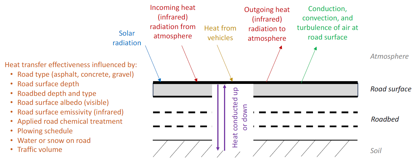
Figure 2. Physics-based road surface models account the heat transfer into and out of the road surface, so road temperature can be computed and the state of water (liquid or solid) on the road can be determined.
These observations tell us lots about what’s happening at the station locations. But what about locations between stations, or along roads with no stations. And how can we forecast future road conditions? For all that we rely on model-based forecasts. Several techniques are used. The most common techniques use physics-based modeling of the road thermodynamics. This is a model that tracks the heat sources going into and out of the road surface and computes how much heat is retained by the road. For example, the sun heats the road during the day, some of that heat is conducted downward through the roadbed into the earth. Also, the road surface heats the air above, and the heat is transferred away by convection and wind. Vehicle traffic even contributes a small amount of heat. An alternate forecasting technique is to measure a characteristic thermal “map” of the road surface temperature. This is done by driving a vehicle with a road temperature sensor along a road at critical times, such as the time of the morning commute. Knowledge of how this measured temperature profile relates to various atmospheric weather conditions can then be used to forecast when and where icy conditions are most likely.
All of this matters. More than one of every five vehicle crashes in the US are weather-related (https://ops.fhwa.dot.gov/weather/q1_roadimpact.htm), with a significant portion related to the condition of the road surface. State and local transportation departments are the traditional users of road weather information to make plowing and treatment decisions that help minimize dangerous conditions like ice. The advent of connected vehicles with sophisticated sensors (such as traction monitoring) means that cars are increasingly capable of delivering road weather information directly to drivers. Moreover, the growing integration of autonomous driving capability, including fully autonomous cars, means that the vehicles themselves are starting to make decisions that rely on this information. As these technologies mature, vehicles will automatically anticipate poor road conditions, avoiding those roads or modifying speed to stay safe.
Road weather is a major contributor to vehicle accidents and to transportation delays. It’s a field with much progress to be made, significant practical benefits to society, and many opportunities for those interested.